While launching a website—Mumbai Climate Action Plan—on August 27, Iqbal Singh Chahal, the commissioner of Brihanmumbai Municipal Corporation (BMC), warned that close to 70 per cent of south Mumbai would be submerged by 2050 due to rising sea levels. Almost 80 per cent of the southern tip, including Nariman Point and Mantralaya, Maharashtra’s seat of power, will be under water by that time. This is an area that houses banks, as well as the offices of foreign consulates, corporate houses and political parties. The iconic Wankhede Stadium, Marine Drive and National Centre for the Performing Arts are situated in this area only. This is mainly manmade land, reclaimed from the Arabian Sea in the 1970s. “If we don’t wake up [to the dangers of climate change], it will be a dangerous situation for the next 25 years,” Chahal said. “The [consequences of climate change] like melting glaciers [and rising sea levels] has come to our doorstep.”
Climate scientists have warned that most of south Mumbai, including Cuffe Parade, Mantralaya, Churchgate, Nariman Point, Umarkhadi, Mohammad Ali Road, Marine Lines, Girgaum, and Breach Candy will face the worst of the flooding by 2050. McKinsey India had released a report in February 2020 issuing a warning on the dangers Mumbai has been facing. The report stated that by 2050, Mumbai will see 25 per cent increase in the intensity of flash floods and a 0.5 metre rise in the sea level. That will affect 2-3 million people living within 1 km radius of the coastline
Visible signs
The World Resource Institute (WRI) India has identified some worrying trends while assessing Mumbai’s vulnerability to climate change—Mumbai is becoming warmer and has seen a substantial increase in extreme rainfall events over the past few years. Since 2007, temperatures have been rising steadily. A substantial increase in heavy rainfall as well as storm events has also been noticed since then.
The data with WRI states that the number of days in which Mumbai faces situations requiring extreme caution has been increasing. These are defined as per the guidelines by National Weather Service, US—a ‘caution day’ is one in which the temperature is between 26-32oC. When it varies between 32-43oC the situation is considered as an extreme caution day. Mumbai sees 174 caution days and 187 extreme caution days per year.
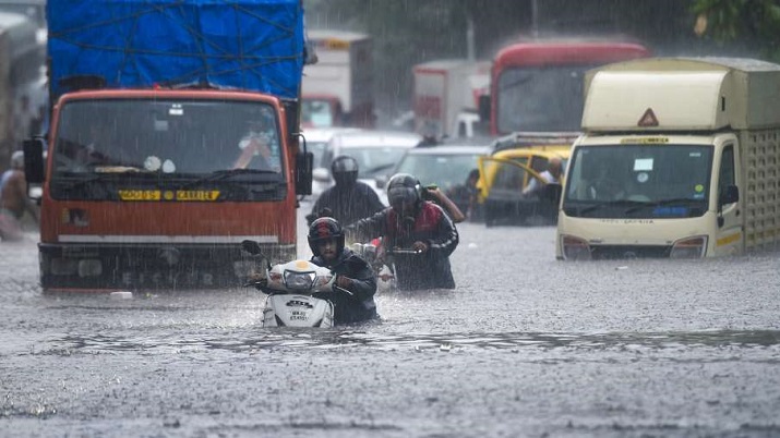
Mumbai has been witnessed two to three days of extreme rainfall during the monsoon in the past couple of years. A major impact of climate change was felt on August 5, when most of south Mumbai was submerged in up to five feet of water due to heavy rain. This year, 70 per cent of the city’s average rainfall in July was received in just four days—from July 17 to 20. On July 16 and 18, Mumbai recorded over 235 mm and 253 mm of rainfall respectively within a few hours leading to flooding in many parts of the city.
Experts warning
According to a study by the UN’s Intergovernmental Panel on Climate Change (IPCC), the surface temperature of the Arabian Sea off Mumbai shore has been rising for close to five decades. Researchers at the Pune-based Indian Institute of Tropical Meteorology (IITM), which has been analysing west coast cyclone landfall data available since 1891, second the IPCC’s view. Roxy Mathew Koll, a climate scientist with IITM, says the Arabian Sea’s surface temperature increased by 1.2-1.4oC between 1982 and 2018—the fastest among tropical oceans. Climate scientist Hiroyuki Murakami, who has studied the Arabian Sea over the past decade, says around 65 per cent of the recent cyclones are linked to climate change.

Surjitt Sahani